Tuesday, September 19, 2017

Travels due to Irma

Irma from a satellite 
Irma was a bitch.  I don’t know how else I can describe the storm.  I’m just thankful that by the time I had to deal with her, she had lost most of her strength and was more of a nuisance than threat to life and limb.  But I can’t forget what she has done to such much of the Caribbean along with the Keys and South Florida.  A friend of mine moved to St. Martin two years ago.  They were able to catch a flight out just before the storm, but everything they had there was destroyed and they’re left with two suitcases of clothes.  The photos from there are devastating, as are the photos of the Keys.  Although the storm passed to the west of us, we had a much higher storm surge than we did last year with Hurricane Matthew. 

In the middle of the cone (9-7-17)
 It is amazing how quickly the weather can change.  We were still watching news about Harvey flooding in Texas when Irma popped up on our radar.  Up until it skirted Cuba, the weather folks had us right in the middle of the cone.  But then it moved further west, bringing destruction to the Keys.  Although we experienced tropical winds, it wasn’t hurricane force winds.  Still, there were few trees blown down on the island, it was nothing like last year. 

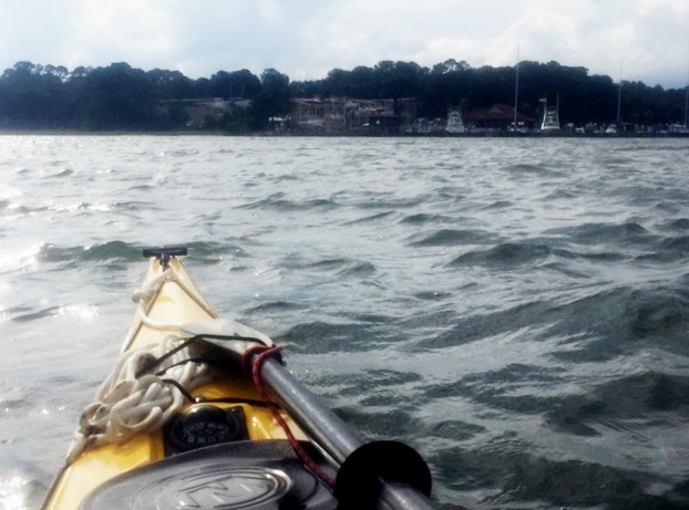
But for a while, Irma looked scary.  Five days out, it appeared she might even miss Florida or bump into Florida’s eastern shore and hit here as a Category 3 o4 4 storm—a major hurricane.  The last major hurricane to strike Georgia was in the 1890s (a decade that saw two such storms). Living on an island meant we were went under an evacuation order beginning, Saturday, September 9.  Many people cleared out before then, and a few who waited till Saturday decided not to leave because by then it was pretty clear the storm had taken a more western track.  I left that Saturday, as planned, having done everything I could to secure property and backed up things at work.  I was glad I’d spent Labor Day (without much thinking about the storm) cleaning out the gutters for the fall and not kayaking. We received just over 7 inches of rain the day of the storm (compared to 12 inches from Matthew).  With nothing more to do, it was time for a hurricane road trip! 

Leaving Coastal Georgia while all of Florida is evacuating is tricky. Thankfully, I had a new downloaded audible book, David McCullough’s The Wright Brothers, giving me over 12 hours of listening.  As Interstates 95 and 75 were creeping along.  Interstate 16, which runs from Savannah to Macon (where it merges with 75 for those heading to Atlanta) wasn’t bad.  They have even closed the eastbound lanes to allow for two more lanes for west bound traffic.  As I was going to stay with relatives northwest of Atlanta, I took I-16 to Dublin, then drove through the countryside on US441, which took me to places that I’d always wanted to see.  I swung through Milledgeville, the old capital of the state.  I have heard much about this town from a fellow blogger, Lynn, I wanted to check it out.  When I told folks here my interest, they thought I was crazy, reminding me it was also the place where the state insane asylum was located.  I also knew it as the home of Flannery O’Conner (who spent her early years in Savannah).
As I made my way up 441, I kept avoiding the bypasses around town and taking the business routes. I just drove through Milledgeville.  In Eatonville, I spied the Uncle Remus Museum.  That was worth stopping, but I learned they’d closed for an early lunch (it was about 11 AM).  I looked around the grounds, then headed over to the Georgia Writer’s Museum.  This was a new museum and they had exhibits mostly on Alice Walker, Flannery O’Conner, and Joel Chandler Harris (of Uncle Remus fame).  I was surprised to see certain folks on the Writer’s Hall of Fame, like Pat Conroy.  While I have enjoyed many of Conroy books, I have never considered him a Georgian.  He’s from South Carolina (and that state needs all the culture boost it can get), but I think he brought gas in Georgia once (or maybe he stayed in an Atlanta hotel for a few nights), so they claimed him.


I left Eatonville, looking for a place to eat. But appeared all the eatin’ places were on the south end of the town and I was heading north, I didn’t find a place to stop and drove on to the delightful town of Madison, named for the President.  I learned that this town hosts an annual Christmas candlelight tour, which would be worth the travel to experience.
African American Museum
(house was built by a former slave)
Madison was one of the towns that was just pillaged and railroad tracks torn up by Sherman and not burned, supposedly because it was the home of one of the Confederate hospitals. The downtown area appeared prosperous and around it was many nice older homes.  I ate at the Madison Produce Company where I had a delightful Cranberry and Pecan Chicken Salad Panini.  It was delicious.  I can’t say the same for the Rosemary and Olive Oil potato chips.  Afterwards, I walked around the town.


They have an African-American museum, which was closed!  I then took the greenway around town, which lead to the train tracks and then around the cemeteries.  There were a couple of section of graves for those who had died in the Civil War (at the hospital).  The tomb stones were all planks of white marble.  Some had names, many were for those who were “unknown.”  I was surprised to find a few slabs with no name, but identified as “Colored” and “Hospital Attendant.”  Later, I saw a sign saying that these marble slabs had been placed in the 1970s and I wonder if they had any idea as who were buried in each grave.  According to another sign, the town maintained segregated cemeteries until the Civil Rights area.  After a pleasant couple hours in Madison, I drove into Atlanta on I-20 and then headed north.

Kirkin' o' the Tartans
While in exile in north Georgia, I worshiped at First Presbyterian in Marietta, which was holding a Scottish Heritage “Kirkin’” Service.  I thoroughly enjoyed the service, from the music to the tartans flying and heard a very good service on heritage.  The preacher spoke about how followers of Jesus need to be careful that in the zeal of celebrating our heritage we not offend others, for we need to remember that Jesus calls us into a new kingdom.


 Knowing that Monday was going to be all rain (as the remnant of the hurricane moved over us), I 
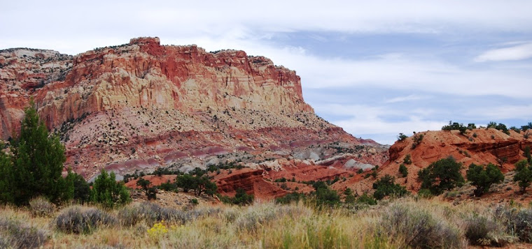
spent Sunday afternoon exploring north Georgia.  
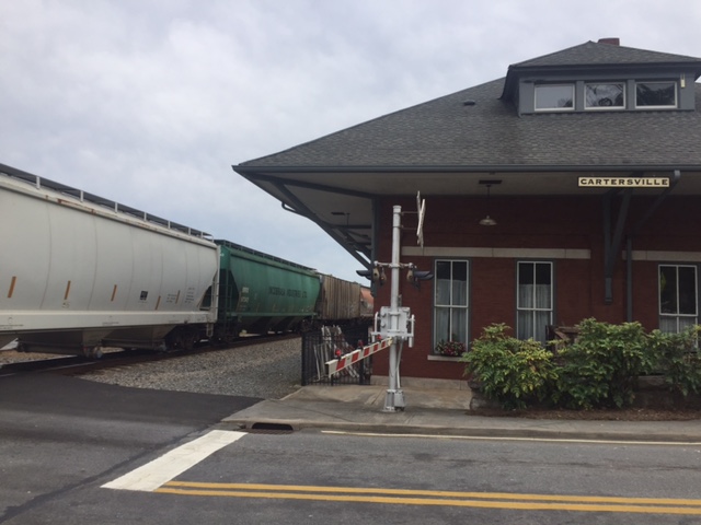
I always like visiting Cartersville (it’s a great place to watch trains) and I walked around the town.  

remains of 19th Century Iron Furance
I also headed over to Cooper’s Furnace, which was an iron making venue in the first half of the 19th Century (it all came to an end with Sherman’s march down through the area on his way to Atlanta and today part of the site around the furnace is at the bottom of Lake Allatoona.  While there, I was able to see a demonstration project for hybrid American chestnut restorations.  The chestnuts were major trees in the Appalachian region of the country but were wiped out early in the 20th Century due to a blight.  Some trees still continue to grow but before they mature, they die back.  The hybrid is an attempt to reestablish the chestnut. 
Allatoona Dam

America Chestnut


Barber Shop roofing in Cartersville

Monday was a day of rain.  I left for home early on Tuesday.  While driving, I finished listening to The Wright Brothers as I tried to cut through the country and avoid the mass parking lot known as I-75 as people headed back to Florida.  Unfortunately, the area between Atlanta and Macon received a lot wind and there were many trees down and the power was mostly out, so instead of sitting on the interstate, I sat on US23, waiting in long lines to get through one stoplight towns (with a stoplight not working, causing traffic back up).  I returned home late in the afternoon, to a bunch of limbs in the yard, but thankfully no down trees and no flooding.  Unfortunately some on this island were not as lucky as the storm surge moved in and flooded many garages and a large number of cars and golf carts was destroyed.  

Friday, September 15, 2017

Hampton Plantation (and an Irma update)

The last week has been crazy.  A week ago, Hurricane Irma seemed to have us in her sights.  The whole coastal area of Georgia went under mandatory evacuation on Saturday.  They later rescinded the evacuation for all but the islands (I live on one of those islands) but by then I was half way across the state.  I left Saturday and came back home to a messy yard on Tuesday.  Thankfully, I only have a lot of clean up.  Although there was a lot more flooding this year than from last year’s hurricane, there were only a few trees down (last year somewhere between 10,000 and 12,000 trees were down just on his island).  I had written his before the quick evacuation and never had time to post it. 
____
Front of Hampton Plantation
the Washington Tree to the left

 On my way back from North Carolina a couple of weeks ago, I took the long way down US 17.  Actually, this route is a bit shorter in miles, but takes a lot more time.  It’s not interstate and you get the pleasure of going through many towns and seeing different sights.  I took this route in order to make a slight detour to visit Hampton Plantation. As I wrote about in a recent review, I have discovered the writings of Archibald Rutledge.  He was born at Hampton in the 19th Century and the last person to live on the plantation.  Having grown up at Hampton, he later inherited the home. After a teaching career in Pennsylvania, he moved back to the plantation in the 1930s and spent the rest of his life restoring it as he devoted the remaining decades of his life to writing.  Shortly afterwards moving back South, he was honored with the title of the South Carolina poet laureate, a title he held till his death in 1973.  In 1970, Rutledge sound the plantation to the South Carolina.

old rice dikes
It was a hot day and I was sweaty after just walking from my car to the ranger’s office.  It was about 1 PM and I learned there would be a tour of the house at 2 PM.  I signed up and then back to my car where I liberally applied insect repellent before walking through an interpretative area about the slaves who used to work the rice fields around Hampton Plantation.  Some of the dikes are still in place as well as some of the water controls that worked with the tides to flood the fields with fresh water.  The markers make it clear that the ones who were to credit with the wealth of the families who lived in the plantation were the slaves.  I also walked down to where Rutledge’s grace is located.

Hampton Plantation had a long history, going back into the pre-Revolutionary War days.  The early residents (ancestors of Archibald) were Horrys (Horry County is where Myrtle Beach is located) and  Pinckneys (that family also owned a plantation that is now a wildlife refuge near Hilton Head).  As friends of George Washington, he stayed here on his Presidential Southern Tour.  Supposedly,   Horry wanted to chop down a large live oak that blocked his view of his horses, but George having become a tree hugger after that cherry tree incident of his youth, pleaded for him to keep the tree.  The “Washington Tree” still stands and is huge.  Up in between some branches, there is a bell that dates back to the early 19th Century and was used to call folks to the dinner table or assemble people when there was danger.

During the tour of the house, we were told stories about where Francis Marion (the Swamp Fox) was sitting when a contingent of Red Coats came riding up.  There was a trap down downstairs and the Swamp Fox was able to go out the back and hide in the swamp.  The plantation had a lovely ball room that covered the eastern side of the house.  When talking with the guide about life at the plantation during the summer, the ranger quickly reminded us that the owners never stuck around during the summer.  Rutledge would head up into the North Carolina Mountains during the summers he spent there.  Later in his life, he spent his summers a waterfront house in McClellandville.  I wonder how his lovely portrayals of Hampton might have changed if he spent his summers there working in the rice fields?

Another interesting thing in the house was a crack in the chimney and wall in the ball room.  This all came from the 1886 earthquake.  This 7.3 quake brought much damage and death to Charleston, SC.

Back side of house (the kitchen house to right and out of view)
Visiting Hampton was a nice way to divide my drive into parts and allowed me to stretch my legs as I got to see things that helped me better appreciate the writings of Ruthledge.  Click for my review of Rutledge's  God's Children.   John Lane in his paddle along the Santee (Hampton is located a few miles from the Santee on a creek that flows into the larger river), also refers to the Hampton and Rutledge.


Monday, September 04, 2017

Paddling Across Romerly Marsh


Leaving Delegal Creek
(notice empty osprey nest)
They changed the weather forecast for Friday so I thought I would take my kayak out to an extended trip.  I launched at Delegal Marina a little before ten, knowing that I had just over an hour before the tide turned.  The winds were stronger than expected, coming out of the south, which provided resistance as I paddled out of the creek.  By the time I was in Ossabaw Sound, the wind was coming off my starboard side and I found the skeg worked wonderfully as I maintained a straight line toward the south end of Wassaw Island.  The last mile or so, as I paddled by the shoals off Pine Island, the waves began to build.  As I crossed the entrance to Wassaw Creek, I was paddling in three foot waves.  The boat handled perfectly.  I made the five mile paddle to the island by 11:15 (which would be close to 3.5 miles an hour which wasn’t bad with the waning tide).  

Ranger station on Wassaw
Normally I would be ready to crawl out of the boat, but it was so comfortable that I paddled about a mile and a half up into Wassaw Creek, stopping at the ranger station for the National Wildlife Refuge.  There was no one there, except for a couple of fishermen who had decided to hole up under their dock.  They fished there, in the shade for over an hour and I think they caught one fish.  I pulled out on a sandy beach a ways down from the station, took out my lunch and hammock, and found two perfectly spaced trees up on a high bluff where I could enjoy a nice breeze.  I strung the hammock and then had lunch.  


Lunch stop
Lunch stop
The Good Life
My original plan had been to return the way that I came or back through the Odingsell River, but I have always wanted to try to paddle through Romerly Marsh to the north end of Skidaway Island. I’ve done this before, paddling in the ocean, but I wanted to go through the marsh.  I figured it would still be close to 17 miles (the distance it is in the ocean) due to the curves in the creeks.  I knew there is a dredged cut I’d have to find, and it’s not very wide. I made a call to get picked up at the Priest Landing marina and headed out about 1:30.  I was hoping to be back around 3:30, well before any afternoon thunderstorm.

This turned out being harder than I thought.  The map showed the cut being further from the Parson family holdings on the island than I thought (they were close to the docks), which I discovered after spending an hour going down false leads.  When I made it back into the main creek, saw someone on the Parson family dock, I paddled over and asked if they could help me.  They pointed me to the right channel, told me to take the second left, which would be marked with a PVC pipe.  I never did see a pipe (in a kayak I’m a lot lower than someone standing in a boat).  I got lost again, but thirty minutes later I had found the cut.  Each time I got lost, I had to paddle back against the tide.  By this point, I was tired. I had also broken a paddle, but thankfully had another with me.

The Parson family purchased the island in the 1860s.  In 1969, they sold all but a 150 or so acre holding to the Nature Conservancy for one million dollars. They, in turn, sold the island to the government to be used as a wildlife refuge. This kept the island from being developed and it is considered one of the most natural islands along the Georgia coast, since it has never been farmed, logged, or used for raising livestock.  The only development on the island are several homes in the Parson holdings, the Refuge ranger's station, and a Spanish American War era battery on the north end that is slowly eroding away.

The marsh is an interesting area.  There are a number of hardwood hammocks within the marsh (with live oaks and sort) and these trees were filled with a variety of birds.  I saw several osprey, ibis, egrets, a variety of ducks, sea gulls and pelicans.  I love watching pelicans fish and one dove into the water not more than 20 feet from my boat, making a big splash.  As he came up, he threw his head back and swallowed.  I also saw a couple of alligator in the marsh.  One, I surprised as I paddled around a bend.  He jumped out into the water and almost hit my boat as he dove under it. 

Dead end
As I floundered in the marsh, I kept looking for where the tide was going against me as I headed in the right direction, for I knew then I’d be paddling out toward the Wassaw Sound.  High tide wasn’t until 5:20 PM, at which time I could probably make it through over the marsh grass, but then I would have to paddle against the tide back to the marina.  When I found the cut and where the tide changed directions, it felt good, as I was now sure that I had only a couple of miles before I would be in Wassaw Sound (and then five more miles before I was at my destination). 

In Wassaw Sound
Once in Wassaw Sound, I turned inland.  In the distance, a storm was brewing.  It was already after four.  I would paddle hard for a bit and then rest.  Thankfully the ocean breeze was strong and to my back, as it gave me a push and also kept the thunderstorm from moving over me.  Instead, the storm moved north, parallel to the coast.  Yet, it was close enough that I saw a dozen or so strikes of lightning.   Once I entered the Wilmington River (where I regularly sail) I felt safe. 


I arrived at the marina at 5:40 PM.  I figured I’d paddled over 20 miles, but I had fulfilled my goal of paddling across the marsh.  

Destination in sight
(notice broken paddle)

The Skeg (photo to answer questions below)