Showing posts with label travels. Show all posts

Tuesday, February 27, 2018

Processional on the First Sunday of Lent


Colored Sawdust used to create mat

In February, as Lent approaches, the Jacaranda trees which are all around Antigua, Guatemala bloom. Their purple petals are royal in color and set the scene for the season. Antigua is known for it's processionals and on each Sunday in Lent, A processional will begin at a church on the edge of town and wind its way toward the site of the old cathedral at the City's Center. I was blessed to be in Antigua for the first such processional for 2018.  In preparation, large colorful designs made of flowers and/or colored sawdust, are placed along the route of the processional. 
Flowers are used for this mat


Those with banners lead the processional 
While the processional is still a ways away, young men with banners began to make their way down the street as the music from the band can be heard long before one sees the musicians.

The largest float with the suffering Jesus
As the processional approaches, priests swing censers filling the air with incense.  Immediately my head began to react to the smell and I realize why I could never be a Catholic, Orthodox or Buddhist priest (there's other reasons, but my allergies is at the top of the list). 


The floats are carried on the shoulders of men who wear purple robes.  Those who carry the float are exchanged each block.  As they slowly move forward, the float seems to rock back and forth. Time seems to appear to slow down as the float waddles down the street carried by local men.
The statue of Jesus carrying the cross provides a visual that goes well with the mournful sounds coming from the band.

The band follows the Jesus float, providing a mournful tune to encourage those who are a witness to the processional to reflect on their sins and on our human role in crucifying the Savior.

Following Jesus is a float of the blessed mother of the Savior, Mary.

I think these were statues of Mary and Joseph.

As soon as the processional passed, men were out with shovels and racks to clean up the streets. The vegetation and sawdust was tossed into a front-end loader who would dump the waste into the back of waiting pickup trucks.

It was over in 30 minutes. Even though my head was clogged, it wouldn't have missed this experience.  It was also beautiful and mysterious.  

Thursday, February 22, 2018

Back from Guatemala

Mt. Fuego puffing away
On Tuesday evening, I returned from an eleven day trip to Guatemala.  I went on a mission team and as no good deeds go unpunished, I came back with one heck of a congested head that has sapped my strength.  Over all, it was a good trip.  We started and ended in Antigua, which is a lovely old city.  But we spent four nights in Jalapa, a town in the southeast of the country, from which we ran clinics in two smaller villages.  When we returned to Antigua, the volcano that overlooks the city had become quite active, or at least it was sending up enough smoke to remind folks of its presence. 


I loved the climate (we were mostly above 4000 feet).  Nights were cool, days were warm.  I also enjoyed the food--lots of vegetables and fruit, good meats, wonderful spices and sauces, and cold beer!  Maybe I'll write more later (but I still have more to write about my summer trip to Scotland).

Chicken in Pepian Sauce

Tuesday, September 19, 2017

Travels due to Irma

Irma from a satellite 
Irma was a bitch.  I don’t know how else I can describe the storm.  I’m just thankful that by the time I had to deal with her, she had lost most of her strength and was more of a nuisance than threat to life and limb.  But I can’t forget what she has done to such much of the Caribbean along with the Keys and South Florida.  A friend of mine moved to St. Martin two years ago.  They were able to catch a flight out just before the storm, but everything they had there was destroyed and they’re left with two suitcases of clothes.  The photos from there are devastating, as are the photos of the Keys.  Although the storm passed to the west of us, we had a much higher storm surge than we did last year with Hurricane Matthew. 

In the middle of the cone (9-7-17)
 It is amazing how quickly the weather can change.  We were still watching news about Harvey flooding in Texas when Irma popped up on our radar.  Up until it skirted Cuba, the weather folks had us right in the middle of the cone.  But then it moved further west, bringing destruction to the Keys.  Although we experienced tropical winds, it wasn’t hurricane force winds.  Still, there were few trees blown down on the island, it was nothing like last year. 

But for a while, Irma looked scary.  Five days out, it appeared she might even miss Florida or bump into Florida’s eastern shore and hit here as a Category 3 o4 4 storm—a major hurricane.  The last major hurricane to strike Georgia was in the 1890s (a decade that saw two such storms). Living on an island meant we were went under an evacuation order beginning, Saturday, September 9.  Many people cleared out before then, and a few who waited till Saturday decided not to leave because by then it was pretty clear the storm had taken a more western track.  I left that Saturday, as planned, having done everything I could to secure property and backed up things at work.  I was glad I’d spent Labor Day (without much thinking about the storm) cleaning out the gutters for the fall and not kayaking. We received just over 7 inches of rain the day of the storm (compared to 12 inches from Matthew).  With nothing more to do, it was time for a hurricane road trip! 

Leaving Coastal Georgia while all of Florida is evacuating is tricky. Thankfully, I had a new downloaded audible book, David McCullough’s The Wright Brothers, giving me over 12 hours of listening.  As Interstates 95 and 75 were creeping along.  Interstate 16, which runs from Savannah to Macon (where it merges with 75 for those heading to Atlanta) wasn’t bad.  They have even closed the eastbound lanes to allow for two more lanes for west bound traffic.  As I was going to stay with relatives northwest of Atlanta, I took I-16 to Dublin, then drove through the countryside on US441, which took me to places that I’d always wanted to see.  I swung through Milledgeville, the old capital of the state.  I have heard much about this town from a fellow blogger, Lynn, I wanted to check it out.  When I told folks here my interest, they thought I was crazy, reminding me it was also the place where the state insane asylum was located.  I also knew it as the home of Flannery O’Conner (who spent her early years in Savannah).
As I made my way up 441, I kept avoiding the bypasses around town and taking the business routes. I just drove through Milledgeville.  In Eatonville, I spied the Uncle Remus Museum.  That was worth stopping, but I learned they’d closed for an early lunch (it was about 11 AM).  I looked around the grounds, then headed over to the Georgia Writer’s Museum.  This was a new museum and they had exhibits mostly on Alice Walker, Flannery O’Conner, and Joel Chandler Harris (of Uncle Remus fame).  I was surprised to see certain folks on the Writer’s Hall of Fame, like Pat Conroy.  While I have enjoyed many of Conroy books, I have never considered him a Georgian.  He’s from South Carolina (and that state needs all the culture boost it can get), but I think he brought gas in Georgia once (or maybe he stayed in an Atlanta hotel for a few nights), so they claimed him.


I left Eatonville, looking for a place to eat. But appeared all the eatin’ places were on the south end of the town and I was heading north, I didn’t find a place to stop and drove on to the delightful town of Madison, named for the President.  I learned that this town hosts an annual Christmas candlelight tour, which would be worth the travel to experience.
African American Museum
(house was built by a former slave)
Madison was one of the towns that was just pillaged and railroad tracks torn up by Sherman and not burned, supposedly because it was the home of one of the Confederate hospitals. The downtown area appeared prosperous and around it was many nice older homes.  I ate at the Madison Produce Company where I had a delightful Cranberry and Pecan Chicken Salad Panini.  It was delicious.  I can’t say the same for the Rosemary and Olive Oil potato chips.  Afterwards, I walked around the town.


They have an African-American museum, which was closed!  I then took the greenway around town, which lead to the train tracks and then around the cemeteries.  There were a couple of section of graves for those who had died in the Civil War (at the hospital).  The tomb stones were all planks of white marble.  Some had names, many were for those who were “unknown.”  I was surprised to find a few slabs with no name, but identified as “Colored” and “Hospital Attendant.”  Later, I saw a sign saying that these marble slabs had been placed in the 1970s and I wonder if they had any idea as who were buried in each grave.  According to another sign, the town maintained segregated cemeteries until the Civil Rights area.  After a pleasant couple hours in Madison, I drove into Atlanta on I-20 and then headed north.

Kirkin' o' the Tartans
While in exile in north Georgia, I worshiped at First Presbyterian in Marietta, which was holding a Scottish Heritage “Kirkin’” Service.  I thoroughly enjoyed the service, from the music to the tartans flying and heard a very good service on heritage.  The preacher spoke about how followers of Jesus need to be careful that in the zeal of celebrating our heritage we not offend others, for we need to remember that Jesus calls us into a new kingdom.


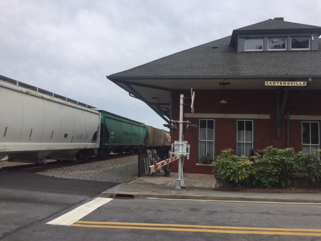
 Knowing that Monday was going to be all rain (as the remnant of the hurricane moved over us), I spent Sunday afternoon exploring north Georgia.  I always like visiting Cartersville (it’s a great place to watch trains) and I walked around the town.  

remains of 19th Century Iron Furance
I also headed over to Cooper’s Furnace, which was an iron making venue in the first half of the 19th Century (it all came to an end with Sherman’s march down through the area on his way to Atlanta and today part of the site around the furnace is at the bottom of Lake Allatoona.  While there, I was able to see a demonstration project for hybrid American chestnut restorations.  The chestnuts were major trees in the Appalachian region of the country but were wiped out early in the 20th Century due to a blight.  Some trees still continue to grow but before they mature, they die back.  The hybrid is an attempt to reestablish the chestnut. 
Allatoona Dam

America Chestnut


Barber Shop roofing in Cartersville

Monday was a day of rain.  I left for home early on Tuesday.  While driving, I finished listening to The Wright Brothers as I tried to cut through the country and avoid the mass parking lot known as I-75 as people headed back to Florida.  Unfortunately, the area between Atlanta and Macon received a lot wind and there were many trees down and the power was mostly out, so instead of sitting on the interstate, I sat on US23, waiting in long lines to get through one stoplight towns (with a stoplight not working, causing traffic back up).  I returned home late in the afternoon, to a bunch of limbs in the yard, but thankfully no down trees and no flooding.  Unfortunately some on this island were not as lucky as the storm surge moved in and flooded many garages and a large number of cars and golf carts was destroyed.  
Friday, September 15, 2017

Hampton Plantation (and an Irma update)

The last week has been crazy.  A week ago, Hurricane Irma seemed to have us in her sights.  The whole coastal area of Georgia went under mandatory evacuation on Saturday.  They later rescinded the evacuation for all but the islands (I live on one of those islands) but by then I was half way across the state.  I left Saturday and came back home to a messy yard on Tuesday.  Thankfully, I only have a lot of clean up.  Although there was a lot more flooding this year than from last year’s hurricane, there were only a few trees down (last year somewhere between 10,000 and 12,000 trees were down just on his island).  I had written his before the quick evacuation and never had time to post it. 
____
Front of Hampton Plantation
the Washington Tree to the left

 On my way back from North Carolina a couple of weeks ago, I took the long way down US 17.  Actually, this route is a bit shorter in miles, but takes a lot more time.  It’s not interstate and you get the pleasure of going through many towns and seeing different sights.  I took this route in order to make a slight detour to visit Hampton Plantation. As I wrote about in a recent review, I have discovered the writings of Archibald Rutledge.  He was born at Hampton in the 19th Century and the last person to live on the plantation.  Having grown up at Hampton, he later inherited the home. After a teaching career in Pennsylvania, he moved back to the plantation in the 1930s and spent the rest of his life restoring it as he devoted the remaining decades of his life to writing.  Shortly afterwards moving back South, he was honored with the title of the South Carolina poet laureate, a title he held till his death in 1973.  In 1970, Rutledge sound the plantation to the South Carolina.

old rice dikes
It was a hot day and I was sweaty after just walking from my car to the ranger’s office.  It was about 1 PM and I learned there would be a tour of the house at 2 PM.  I signed up and then back to my car where I liberally applied insect repellent before walking through an interpretative area about the slaves who used to work the rice fields around Hampton Plantation.  Some of the dikes are still in place as well as some of the water controls that worked with the tides to flood the fields with fresh water.  The markers make it clear that the ones who were to credit with the wealth of the families who lived in the plantation were the slaves.  I also walked down to where Rutledge’s grace is located.

Hampton Plantation had a long history, going back into the pre-Revolutionary War days.  The early residents (ancestors of Archibald) were Horrys (Horry County is where Myrtle Beach is located) and  Pinckneys (that family also owned a plantation that is now a wildlife refuge near Hilton Head).  As friends of George Washington, he stayed here on his Presidential Southern Tour.  Supposedly,   Horry wanted to chop down a large live oak that blocked his view of his horses, but George having become a tree hugger after that cherry tree incident of his youth, pleaded for him to keep the tree.  The “Washington Tree” still stands and is huge.  Up in between some branches, there is a bell that dates back to the early 19th Century and was used to call folks to the dinner table or assemble people when there was danger.

During the tour of the house, we were told stories about where Francis Marion (the Swamp Fox) was sitting when a contingent of Red Coats came riding up.  There was a trap down downstairs and the Swamp Fox was able to go out the back and hide in the swamp.  The plantation had a lovely ball room that covered the eastern side of the house.  When talking with the guide about life at the plantation during the summer, the ranger quickly reminded us that the owners never stuck around during the summer.  Rutledge would head up into the North Carolina Mountains during the summers he spent there.  Later in his life, he spent his summers a waterfront house in McClellandville.  I wonder how his lovely portrayals of Hampton might have changed if he spent his summers there working in the rice fields?

Another interesting thing in the house was a crack in the chimney and wall in the ball room.  This all came from the 1886 earthquake.  This 7.3 quake brought much damage and death to Charleston, SC.

Back side of house (the kitchen house to right and out of view)
Visiting Hampton was a nice way to divide my drive into parts and allowed me to stretch my legs as I got to see things that helped me better appreciate the writings of Ruthledge.  Click for my review of Rutledge's  God's Children.   John Lane in his paddle along the Santee (Hampton is located a few miles from the Santee on a creek that flows into the larger river), also refers to the Hampton and Rutledge.


Monday, August 28, 2017

Trail Report from August 13: White Pine Nature Preserve


White Pines
I spent a week in the Sandhills of North Carolina planning my upcoming year.  Several evenings I took off for a little hiking.  One of these evenings was the White Pines Nature Preserve which sits at the confluence of the Rocky and Deep River, between Sanford and Pittsboro in Chatham County.  This is a unique 275 acres with a micro-climate that allows species of trees and plants that have long been extinct in other parts of the Piedmont of North Carolina to survive.  The merger of the two rivers and the northern slopes of the ridges provide a cooling effect which I immediately felt when I stepped out of my car.  It was around 5:30 pm, at the end of a hot and humid day.  Although it felt cooler, it was still hot.  Here’s my report.


I set off down the White Pines trail, which followed the ridge between the two rivers.  I was curious about seeing a white pine, a tree that I knew well in Michigan and are only seen in mountainous areas in the South. A few hundred yards into my hike, I spotted my first white pine.  The canopy along the top of the ridge is think, shading me for the sun and not allowing a lot of undergrowth.


In this land of long lead pines, the white pine stand out nicely.  Shortly after seeing the first white pine, I come upon two hikers heading out.  As there are two other cars in the parking lot, I assume I’ll soon be alone in the woods.   The trail loses elevation as the ridge dripped down toward the confluence. There’s a nice breeze but I still sweat from the humidity. I take the River Trail, which drops off the ridge to the south, toward the Deep River.  This is the lee side of the ridge and I no longer enjoy a cooling breeze. Coming alongside the river, the undergrowth is thick.  I slap at a mosquito on the back of my neck as I am serenaded by a choir of insects singing their evening vespers. The trail parallels the river, a good ten or so feet above the water.  There are a few places it would be easy to reach the water, which are probably used by fishermen, but most of the trail is separated from the water by a steep bank and a plenty of poison ivy. 
Deep River

Bench at Confluence
I pause at the confluence of the two rivers.  Someone had built a nice log bench to site and enjoy, but the mosquitoes are bad enough that I decide to keep walking, heading up the Rocky River.  In my youth, I paddled both of these rivers, but never had made it down this far, ending both trips at the 15-501 bridges.  The Rocky River, if I remember correctly, was only runnable at high water and we ran it when the Haw River was well above flood stage and too danger to paddle in an open canoe. 


Rocky River
The River Trail turns away from the Rocky and climbs the hill where I joins the White Pine Trail.  Climbing the north side of the ridge, I notice more white pines along with maples, oaks, beech, American holly, hackberry, popular and even a cherry.  The sun is dropping in the west and its rays come in at a low angle providing wonderful light.  I take the White Pine Trail to the cut-off for the Gilbert Yager Trail, which leaves the ridge and funs along the flank of the ridge, cutting in and out of hollows that drain down to the Deep River.  I spook up a couple of deer who run up the hills without pause.  The trail is about a mile in length and drops me back at the far end of the parking lot.  It’s almost 7:30.  Time to find some dinner and prepare for a good night’s rest.  Later that night, I would find two hitch-hikers from my travels (ticks) which I promptly dispatched down the drain.  Thankfully, they hadn't yet dug into my skin.  

Monday, August 07, 2017

A boat trip to Staffa

In my last post about Iona, I suggested that Staffa needed a post on it's on.  Here it is.  
For more about my week in Iona, see my previous post.

On Monday of my week on Iona, the weather had calmed.  I’d signed up for an optional trip that afternoon to the island of Staffa, about ten kilometers from the dock on Iona.  After lunch, about forty of us gathered at the dock and crammed into a small but very seaworthy boat for the trip to the island.  We sailed across the sound to Fionnphort, where we picked up more passengers.  Although the boat appeared able to handle rough seas, I was glad it was calm.  With so many people on board, I’m sure more than a few would have been seasick in rough seas and there wasn’t enough railing for everyone to hang over the side.  

The ride over

It was a smooth and pleasant ride, so smooth that the captain was able to maneuver the ship into one of the more notable features on the island, Fingal’s Cave.  He said that this was something he could only rarely do as the waves often made it impossible.  The jagged rocks that lined each side of the approach into the cave would have done a number on the hull if he had struck them.  If I was at the helm, I wouldn’t have attempted this maneuver even on a calm day, but he slipped the boat into the cave and then backed it out without a problem.

Sailboats at mooring


Inside Fingal's Cave
Staffa is one of the smallest islands in the Inner Hebrides.  It’s just a little over a kilometer long and half a kilometer wide, with a land mast of 82 acres.  The island sits upon large columns of basalt, having been formed by volcanic activity 50-some million years ago.  While there is a layer of soil on the top allowing for grass and wildflowers to grow, the black rock is very visible.  These columns are mostly hexagonal in shape, and stand up straight.  They were formed by the cooling of the lava and have created several large caves in addition to Fingal’s Cave.  The island was named by the Vikings, who were reminded of their log homes by the basalt columns on the island. 

Approach to Fingal's Cave
We were not the only group on Staffa.  Tour boats come from Ulva, Oban as well as Iona and Fionnphort.  Hordes of people were on mulling around the island.  There were also a number of private boats including a couple of sailboats that had moored off the island and taken tenders over to the docks.  Staffa has been a stopping area for those touring the islands since the 18th Century.  This is a small dockage area on the east side of the island.  With only an hour, I took off south along the basaltic columns in a return to Fingal’s Cave, which was named from a mythological Irish warrior.  

The echo of the waves inside the cave, which was best heard without the drone of the boat’s engine, supposedly inspired Felix Mendelssohn to compose Die Hebriden, or “The Hebrides Overture.” 

Photographing Puffins
After a few minutes, I headed to the north cliffs off the island, where puffins nest along the cliffs.  We had been told to sit still on the edge of the cliff, as the puffins will come to check us out.  Supposedly, they don’t go on top of the landmass during the day, as the seagulls will often attack and kill them.  But the gulls don’t like people, so when we’re present, the Puffins have learned it is safe to come up above the cliff.  These birds mostly spend their day flying back and forth from the sea below to the cliffs, where they tend their young.  In early August, the young begin their flight and soon all the birds fly off into the North Atlantic where they spend the winter. It appears to me that these beautiful birds led the most miserable life, but I was glad to be able to see them so close (a couple came up within a few feet of me). 
Aren't they cute!


West side of Staffa
A seal sunning

There was not enough time to fully explore the island.  Soon, I was rushing back to the boat (and the next to last to board).  On our way back, we were able to see seals sunning off the west side of Mull.  We arrived back in Iona in time for a late afternoon tea.
Looking back at Iona

Friday, August 04, 2017

A Week on Iona

Sunset from Dun I
 Life on Iona, as a part of the community, consists of a rhythm.  There’s a bell at 7:15 to wake you up but I was up long before then as the sun was up around 4 AM.  My assigned chores was to light the fire in the hearth in the dining room (as it was often cold and wet in the mornings), then help set the table for breakfast.  We ate at eight.  After the tables were cleared, we headed over to the Abbey for morning prayers, followed by chores.  I was back in the kitchen, chopping up vegetables and fruits for lunch and dinner.  Most meals were vegetarian and quite good.  Roasted cauliflower or root vegetables, hearty soups and such. They tried to use local produce.  After chores, there were group meetings. I was in a poetry group that was led by two British professors, both poets.  During the year, one taught English at her university and the other taught theology.  We met for an hour and a half to two hours. 
Abbey in the evening
Larger view of Abbey in Evening

The Nunnery on Iona
At 1 PM, there was lunch.  It was amazing to see what our cook had prepared with the chopped vegetables.  The afternoons were generally free.  One afternoon, I took a boat trip to the Isle of Straffa (it deserves its own post). One day, we took a long walk (maybe seven miles) around the island, stopping for contemplation and to learn about the island.  While I appreciated the history, I wish the guides were a little more prepared to also discuss geology and plant-life, as much of this was foreign to me.  On the day, a group of us had a very short swim in one of the bays.  It was cold, colder than a summer dip in Lake Superior between the United States and Canada, or Lake Baikal in Russia (Or maybe I’m just getting older).  Some afternoons I took a nap or read.

Chapel to left is a burial ground for islanders and kings

North End of Iona
At 4 PM, we’d gather for tea.  If it was rainy, as it often was, we’d take our tea by the hearth in the dining room, where we’d dry out and enjoy a “biscuit” (cookie for Americans) and some tea or coffee.  At six was dinner, followed by evening prayers in the chapel.  These services were special as the sun coming in from behind gave a warm light to the chapel (I posted a photo of the inside of the chapel a few weeks ago). Some nights were free, others there were events such as dancing in the town hall.  On the last evening, there was a talent show, with stories and songs from various parts of the world where we’d all come.  A couple of evenings, I’d take a walk down to one of the hotels or the bar for internet access and a drink of some of Scotland’s finest.  Afterwards, I’d walk, often up to the top of Dun I, the high point on the island (about 330 feet above sea level).  As it was late June, the sun was setting around 10:30 PM and it never really turned totally dark.  Several evenings, I sat on Dun I till nearly midnight and had no problem making it down in the twilight without a flashlight (or torch, as the British call it).  One night, it got dark enough and there was enough break in the clouds that I was able to see two stars.  It was after midnight!
Twilight, looking north 


That's me on the South End of Iona
It was a delightful and restful week.  
South end of Iona (notice golf course in sheep's pasture)