|
| Sage (turn your computer 90 degrees) |
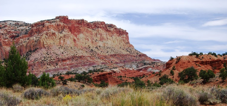
The first couple hundred yards is on a boardwalk leading to
the Lake of the Clouds overlook.
Lots of
people are here, including a dozen or two Harley riders.
Everyone takes the short walk to the platform
that provides a marvelous view at the escarpment and the lake below, some are
complaining as if they are on a real trek.
I feel a little out-of-place with my pack and leather boots in a crowd
wearing sandals and flip-flops. The only other boots are worn by the Harley
riders.
At the overlook, an interpretive
sign informs us that the lake was originally called Carp Lake, the same name as
the rivers that drain this area.
I’m planning
on hiking down Little Carp River, which supposedly is a wonderful stream for
brook trout, and the name “Carp” had me worried.
The sign reassured me that there are no carp
in these waters and the name had come out of the French word for “escarpment.”
The French, who were the first Europeans to
explore this area, left behind a lot of names.
 |
| Outlet for Lake of the Clouds |
Leaving the overlook at the top of the basalt escarpment,
the trail snakes steeply downhill for maybe a half of a mile, coming to a bridge
that crossed the outlet for the Lake of the Clouds. There are a couple of backpackers getting
water at the bridge and they informed me that the campsites along Mirror Lake
had been crowded. There are several
campsites on the east side of the lake still open (camping is first come/first
serve), so I decide that even though it was only four o’clock, to stop for the
night, set up camp and then explore the lakeshore. It is a short first day of hiking, only a
little over a mile by the time I get to the campsite. I explore the east shore of the lake, then eat
dinner and relax in my hammock reading a book of Rick Bragg’s newspaper
columns, before going back to the lake to watch the sunset. It’s an early night. The air is warm and probably because we’d
been in such a drought, there are few bugs.
I crawl into my bivy tent at 9:30 AM, leaving the tarp off as I’m
expecting a clear night. At about 2 AM,
I wake and spend a few minutes looking at the stars before falling back to
sleep.
 |
| Sunrise on Lake of the Clouds |
I rise early on my second morning. After a breakfast of oatmeal and coffee, I
hit the trail at 8 AM, passing other campers who are just getting up. Soon I was back on the main trail as it climbs
steeply up the ridge to the east of the lake.
Although the elevation gain is only about 200 meters, the steep part of
the trail has no switchbacks and feels as if it was straight up, as it
parallels a small stream that had gouged out a narrow canyon in the rock just
south of the trail. This is hemlock country
and the trees that send out roots along near the surface provide barriers that
keep the trail teams from the need of installing erosion dams. But the roots are also tough on the
feet! There is a campsite on the top of
the climb and I take a break and check my blood sugar. This is my first backpacking trip since being
diagnosed with Type I (insulin dependent) diabetes. Although I had purposely taken less insulin
than normal in the morning, I find my blood sugar has dropped and is barely at 100. Normally, it doesn’t drop to that level until
mid-day. I eat a mini candy bar and a
granola bar as I continued hiking on the Mirror Lake. People are beginning to hit the trail and at
the junction of Government Peak Trail, I run into a man and his seven year old
son who had spent the night up on the peak.
 |
| Mirror Lake |
As I approach Mirror Lake, I come across an African-American
man and his two sons.
He asked where I’d
spent the night and when I tell him he looks astonished and asks how long I’d
been on the trail.
When I say a little
less than 2 hour (and I don’t tell him that included a 20 minute break), he shakes
his head and says I must be a fast hiker for they’re hoping to make it to the
lake by the evening.
I’m not exactly
hauling a light load with a heavy DSLR and some extras like a pack rod with
both a spinning and fly reel, a small hammock and added comfort, I’ve left my
thermarest behind for a two inch thick sleeping pad.
My pack probably weighs close to forty-five
or so pounds.
But looking at the size of
his pack (which could have easily weighted eighty pounds) plus the gear hanging
off his belt (a large buck knife, a flashlight and a leatherman® tool and a
pouch), I knew he’d be slower than me, but still expect he make the lake long
before the evening.
At Mirror Lake, I take
a break and talk to a day hiker who arrives as I’m taking photos.
His son has just joined the Marines (he had
been in the Army when he was younger) and he felt the need to get out into the
woods.
There are also people in all the
campgrounds packing up and getting ready to hit the trail.

From Mirror Lake, I picked up the Little Carp River
trail.
For the first couple miles, it runs
through a swampy area between Mirror Lake and Lily Pond.
Often there are boards to walk on, but the
summer has been so dry they are not really necessary.
Through
this section (and only time on this trip) mosquitoes are problematic and splash
a little repellent on which did the trick.
Through this section, there are pockets of huge hemlocks, beech and
maples and I wonder if this virgin timber, too remote to have fallen to the
teeth of saws.
I arrived at Lily Pond a
little before noon.
There is a nice
bridge over the lake’s outlet, just down from a beaver dam, with a bench in the
middle.
Although there is a cabin nearby
(there are rustic cabins throughout the Porcupines for rent), no one appears to
be around.
I pull of f my boots off and
air my toes and then prick my finger to check my blood sugar levels.
Despite having eaten several snacks in the
morning, my blood sugar had dropped to 90, so I decided not to take insulin at
lunch.
It was obvious that I am burning
up the sugar in my bloodstream and I don’t need to risk the insulin driving my
blood sugar even lower.
By the end of a
day of hard hiking, I would come to the conclusion that I can forgo my
rapid-acting insulin at breakfast and lunch and only take it at dinner.
Lunch consisted of peanut butter on raisin
bread along with some cheese and crackers.
 |
| Lily Pond with beaver dam |
While having lunch, a family staying at the nearby cabin marches
by.
The man, a father or grandfather, is
on point.
He nods to acknowledge me when
I said hi, but doesn’t speak.
None of
them does, as if they’re on a covert mission.
Behind him was a son (or grandson, as the man and woman look too old to
have a kid that appeared to be a young teenager) followed by the mother or
grandmother.
What amazes me is their
attire.
They have matching clothes that
make them look like a walking L. L. Bean ad, along with matching walking sticks
(with red tassels and a feather on the end).
On the shoulder straps of their daypacks are walkie-talkies mounted they
were soldiers or police officers on a mission.
Soon, another family comes up for the other
direction and my quiet lunch spot was interrupted with three teenage boys
running around and the banging around in a canoe as they headed out into the
little lake.
I pack up and hit the
trail.
Throughout the afternoon, I found myself deep in thought
over my life and for some reason feeling nostalgic as I recalled friends that I
hadn’t seen in years, places like Columbus County, NC, Central Idaho, Virginia
City, NV and Western New York. I think about
Roscoe and Harold, two very different men who’d served as scoutmasters for
troops in the district I served. I think
about Marge, who served as my western mother when I first directed a camp in
the Sawtooth Mountains of Idaho. She
made it her mission to see that I got to see what the west was all about. I think she also wanted me to take an
interest in one of her daughters, but that hadn’t happened, even though we remained
friends until she succumbed to cancer in the late 90s. I think about Victor and Wendy, friends in
Virginia City and Jerry from Western New York, who’d just emailed me for my
recipe for hushpuppies. As I got the
email on my phone, I decided to wait to return his email. And I think about Ralph, one of my desert
traveling buddies from Utah whom I at times find myself missing. On my drive up, I had spent an hour on the
phone (with a headset) talking to his widow.
We both miss him.
As I think about many of these people, many of whom stories
I’ve written, I find myself wondering if there is a market for such a
collection of stories. And then I
thought about the trails I’ve hiked and the trains I’ve taken and the stories
I’ve written and ponder the idea of a collection titled “Rails and Trails.”
 |
| Little Carp River |
About a mile south of the pond, the trail leaves the river.
The river, which is little more than a creek,
turns east while the trail continues south.
For a few miles climbs as I am lost in my thoughts, I climb over some
low ridges, dropping down where there is a stream.
I meet a group of Boy Scouts having lunch at
one of the streams.
The scouts and their
leaders pass around chucks of cheese and logs of summer sausage which they slice
roll in tortillas and eat them as a burrito.
The trail connects back to the
river at a small falls, where there are some cabins.
The river has now taken a westward turn as it
makes it way toward the big lake.
I take
a long break, napping by the falls before resuming my hike.
The next few miles the trail alternates from
running right next to the stream to climbing up benches above the stream and
hiking through hemlock groves which are like walking on carpet with the thick
blanket of needles covering the ground.
The
soft ground is a treat for I am getting tired and have probably hiked 13 or 14
miles. There are some huge white pines located along this section and again I
wonder if they’re virgin timber that was too remote to cut.
I
decide to stop at a campsite that is just after the trail crosses the river but
when I get there I am saddened to see two other packs.
I drop mine anyway and head over to the
couple who are getting water by a long gradual falls along the river.
They’re not planning on camping, but are
heading on up the river.
We exchange
information about the trail.
When they
leave, I set up camp.
It is 4:30 P.M.
After pitching my tent and finding a good place to hang my
food, as this site didn’t have a bear pole, I go for a swim in the creek. Id’ been hot, sweaty and dirty and the cool
water helps revive my spirits. I try
fishing a bit, throwing a Panther Martin (spinner) into a few holes and catch a
small brook trout, maybe 7 inches long.
This is a special trout stream and they have to be fifteen inches. I have seen a few trout, but nothing that
comes close to the fifteen inch mark.
Afterwards, I head back to camp and fix dinner: rice and curried chilies
(an Indian boil in the bag meal), along with tea. After dinner, I head out to try my luck with
some flies, but don’t get any fish to rise.
Exhausted, I’m in bed a little after nine o’clock.
 |
| Lake of the Clouds from the Escarpment |
To be continued…
###