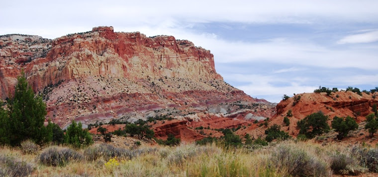
 The wind blew most of the night as I burrowed myself deep in my sleeping bag laid out under the pines, just north of Crazy Jug Point. But when I woke in the morning, the air was finally still. A few birds sang and a bee buzzed around my bag. He must be getting desperate for some nourishment this late in the fall, I muse to myself. It’s the ninth of October and up here on the ridge, winter isn’t too far off. I sit up and, not getting out of the bag, watch the sunrise over the canyon, gazing out toward the
At 10:30 AM, we’d driven over to the Bill Hall trailhead and everyone is ready. In addition to what’s in our packs, we all start out with an extra gallon jug of water. Those eight pounds will be stashed along the way so that we’ll have enough water to make the long dry climb up out of the canyon. I’m able to get the gallon jug in my pack along with three plastic quart jars for water and a pint for whiskey. Since we’re hiking down, I only fill two of my water bottles. By mid-afternoon, I’ll realize that this was a mistake.

The trail runs along the rim for a mile or so before dropping off and then climbing back up to Monument Point. From Monument Point, at 7200 feet, the trail drops quickly through Kaibab and Turweep rock formations. At one point, we shed our packs and lowered them 30 feet or so by rope, freeing us to climb down through a path that twists through the rock. The trail keeps dropping till it joins the Thunder River Trail. By this point, we've lost over 1800 feet. Taking this trail, we head south along the Esplanade, a rather wide bench with small changes in elevation. The trail is mostly over slick rock and marked with cairns Surprise Valley
 The climb down from the Esplanade to
The trail continues south for a ways, and then turns east where it intersects the trail to Deer Creek. There is no shade. There are no trees, only small bushes and cactus. The temperature is now well into the nineties and I am lightheaded for the hiking and lack of water. It’s about two and a half miles from when we enter the valley to the falls, the next water source. To make matters worse, as we get closer to the rim and our next steep descent, we can hear water gushing. At the rim, the trail goes down steep switchbacks and we can see just to our north, Thunder River Falls
I quickly drink my last few ounces, knowing that at the bottom I can drink till I’m content. I find some relief in that the trail is on the west side of the canyon into which we’re descending and soon, we’re in the shade, away from the sun’s rays.
 At the bottom of
By 6 PM, we’re setting up camp under the cottonwoods on a shelf high above the east side of the creek. Everyone is tried. Darkness descends quickly in the canyon. We quickly fix dinner. Bill, who’d shown us fossils of early life found near the falls (800 feet higher than we are here), notes how the rocks here are void of fossils and were formed before life began on earth. It’s amazing to think how old these rocks are. After eating dinner and a shot of whiskey, I’m ready for bed. Sleep comes easy with the sound of rushing water in the background.
-
 I wake up early the next morning to the clucking sound of a turkey walking through camp. I have thoughts of having a Thanksgiving dinner, with this pesky domesticated wild turkey serving as the centerpiece for a feast. The sun’s rays are barely hitting the ridge and I realize it’ll be a long time before it gets to us. I roll out of bed and fire up my stove, heating water for coffee and oatmeal while packing up my gear. Our plans are to go to the river and camp, but Bill and Mark, whose feet are blistered, don’t want to walk any more than required. Phil, Craig and I decide we’ll go on to the river and camp, but we scratch the plan to cross over to Deer Creek, deciding instead to camp at where Tepeats enters the Colorado and then hike back out the same way we descended into the canyon.
The hike along the creek is relatively easy as the trail snakes a cross the creek a couple of times. The river is wide and fast, cold and beautiful. High above the river the banks are lined with rocks and boulders of various shapes, sizes and colors, making it difficult to navigate as some of them are harder to see. Next to the river, there is a narrow sandy beach. There are plenty of barrel cactus and spiny mesquite bushes. By the time we arrive, the sun is up and it’s hot. We pick out a campsite just a ways downstream from the creek and set up a tarp for shade. The only poles we have are our hiking ones, so the tarp isn’t very high, but later in the afternoon when the temperature climbs above hundred, it’s a nice place to nap and read.
-
Shortly after we arrive, a rafting party stops at the mouth of the creek and sets up camp. We walk down to check out the trespassers, worrying that they might spoil the neighborhood, but they’re all cool and are hauling a boatload of beer that’s chilled in the river. The group is mostly made up of river guides, taking their last trip of the season. They offer us each a beer, which does wonders to win our affection. As they’re pulling the beer bag out of the river, they tell us to help ourselves anytime we want a can. We realize that we’ve hit the jackpot, a floating bar along the Colorado
I wake up the next morning just as the first rays of the sun are striking the rim of the canyon. The light sky stands in contrast to the dark walls of the canyon that are still shaded from the sun. I’m stiff. All night my stomach has been in knots. Lying under the screen of my bivy tent, l’d wake and explore the stars and watch meteors speed across the sky before falling back to sleep. All I can really think about is our hike out and hoping that our water cache is safe. In the morning, I think of the seven mile hike ahead, with the 3500 feet elevation gain which mostly comes in the two steep pitches and don’t want to get up from bed. Nonetheless, we make a quick morning of it, hoping to get as many miles done as possible before the day gets too hot. Packed up, we head back up Tapeats Creek.
When we pass our first campsite, we realize Bill and Mark have gone on ahead. We continue on up Thunder River
Leaving Thunder River behind, we begin the switchbacks up to Surprise Valley San Francisco Colorado River . I still have over three quarts of water and with just one major pitch to climb, realize that I could hike out with what I have on my back. When I’m reunited with the gallon of water I stashed, I feel like a rich man. We set up camp and find shady spots to read and nap. Photo from the afternoon of the third day, lounging around. Sage is to the right.
Photo from the afternoon of the third day, lounging around. Sage is to the right.
-
It’s my night for dinner and I’ve planned Mexican. I borrow pots from everyone and as the sun begins dropping in the west, I set out to make rice, using boil in a bag pouches. I have dried re-fried beans to which I add boiling water. I make two instant cheese cakes (which only kind of sets up because of the lack of refrigeration (I normally would set it in a spring or cold stream, but there is no water on the Esplanade). I lay everything out, tortillas, beans, rice, cheese, diced onions and an avocado that I’ve hauled along, along with packages of salsa that I’d accumulated from Taco Bells. We feast on burritos, drinking large quantities of water to rehydrate ourselves. Afterwards, we watch a beautiful sunset. The smoke from control burns makes the sun especially beautiful. After sunset, we are treated to the setting of a new moon. As the lunar sliver approaches the horizon it, too, turns brilliantly red.
That night, I’m still sore when I go to bed, but feel good. For a long time, I lay looking at the skies and stars. Again, I see numerous meteors. I fall asleep and dream of the backyard that I am landscaping at home. In my dream, my daughter is playing on grass and I’m setting on the new patio that planned to build when I get back. But then, in another dream, I am with Lorraine
 The climb out, over the third steep pitch on the trail, is tough but doable. There is that one part where we lowered our packs. Going up, we kept our packs on, but we have to pull ourselves up by hands. The final mile is easy as we walked along the rim and look down at where we had been. Phil had left some beers in a cooler with a block of ice in the back of his truck. The ice had melted, but the beers are still a little cool. There was enough to go around to the six of us (Becky had hiked out with us). We drink the beer, toasting each other and talk for a few minutes. Then we got into our vehicles and head in different directions. Phil and I stop to eat Mexican in Kanab and were back in
###
 I'm on the right.
wow. gorgeous country...nice score on the floating bar as well...ha.
ReplyDeleteI don't think you really hear the wind until you're camping. Then it becomes a part of your life. I guess it's that way with much of nature when we spend so much time tucked away from it.
ReplyDeleteWhat luck - a floating bar! :) The trip sounds wonderful - a good memory.
ReplyDeleteBrings back memories. I hiked up Thunder River, through Surprise Valley and down Deer Creek on my river trip. I reached out and stabilized myself on a cactus somewhere in Surprise Valley and spent a bit of time pulling spines from my hand. I did the entire hike with just one quart bottle for water filling up at the source of Thunder Creek and remember being very dry by the time I got across Surprise Valley to the source of Deer Creek.
ReplyDeleteEnjoyed this, thanks. I have only seen the GC from the southern rim. Your description makes me feel like I've made the trip to the bottom.
ReplyDeleteMost struck by the comment about fossil-free rock dating from before life on earth.
Wow.. what an adventure. Wonderful story and images. Did you keep a journal of the trip back then or do you have a really good memory for details which are over a decade old?
ReplyDeleteBrian, the bar was a nice touch!
ReplyDeleteCharles, I love the wind!
Lynn, yes, it
Ed, I remember the story from your river journals
Ron, it was kind of neat to think about those rock
Hilary, yes, I kept a journal and to write the story, I used the journal, a map of the trail and photos. I've kept a journal (sometimes better than others) for over 30 years.
Gorgeous!
ReplyDeleteI miss the canyon. Tag and I were just talking about hiking to Roaring Springs today.
this sounds more difficult than an ironman, but more fun. (Glad you carry some booze with you)
ReplyDeleteI love to hear the Earth Breathing! You capture her aliveness as well as anyone I've ever read!
ReplyDeleteJohn
You have the best trip photos ever! Such unbelievable beauty that is just out there waiting to be uncovered, and you do....and you capture the greatest of shots, and have the most interesting story to tell about it. Very cool!
ReplyDeleteSweet.
ReplyDeleteI so need a desert fix right now.
Cheers.
Beautiful scenery, but I feel a bit dehydrated and sore after reading this post...and I'm a little envious, too. Sounds like you and your buddies had some memorable times out there in the wild, my friend. No one shares a tale of adventure the way you do...and again, the photos are priceless.
ReplyDeleteI chose the Bright Angel Trail because it has rest stops with water and shade. Maybe I'll stick with that strategy when I do my rim to rim.
ReplyDeleteI'm glad you didn't run out of water.
I was thirsty just reading the first part. I can't imagine how clear and beautiful the sky must have been. As always, thanks for sharing!
ReplyDeleteWow...I love camping and hiking with you. It's...so....effortless.
ReplyDeleteYou've somehow managed to make me thirsty, hot and tired within a few minutes. Kudos to those guides who shared their beer....and I could easily picture those shooting stars.
I kept wanting to yell to you, "FIND A VENDING MACHINE FOR THE WATER!" Not funny, I know...
You make me want to go west like I use to do for a hiking vacation. :)
ReplyDeleteI shouldn't be jealous about 12 yo trips but I am.
ReplyDeleteI just read my dream hike here!!!!
ReplyDeleteI am just into my 3rd year of backpacking into the wild- and I'm addicted.
This sounds like one incredible hike.
Adding this one to my Bucket List!
Thanks for the insight into your days out there.
No doubt to say that you guys spent a very nice time at Grand Canyon. I enjoyed Grand Canyon Hiking at very early of the year 2010. It was one my memorable time in my life.Congratulation to all of you guys.
ReplyDeleteThanks