 |
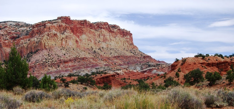
| Sage at the beginning trailhead |
I promised Randall Sherman a year or so ago that I'd write up my account of hiking the John Muir Trail. Here is my first installment. These hikes occured in 1995-1997.
I woke up to a call for passengers for Los Angeles to begin boarding. It was still dark and not yet 6 AM and it took a few minutes for me to gather my bearings. I was sleeping on the ground, next to my car, on the far end of the parking lot at the Inyokern airport. It had been Eric’s suggestion that we bivouac in the parking lot of an airport. We’d been looking for a cheap hotel with vacancy and none had been found since leaving I-15. It was well after 1 AM when Eric spotted the airport search light. As a pilot, he assured me he’d slept many times under his plane and no one would have a problem with us sleeping there. I agreed; I was exhausted. I didn’t even know Inyokern had commercial flights. The call for the LAX came in again as a few cars pulled up and guys with briefcases and carry-ons rushed toward the small terminal. The small airport was coming to life. As it had been the night before, here in the low desert, the air was still warm. A light breeze was blowing, but that would be soon gone and as the sun rose, the day would quickly heat up. I wasn’t going back to sleep. I got up and stuffed my sleeping bag (which I’d slept on top of, and rolled up my pad and stowed it all in the back of the car. Eric, who’d been sleeping on the shotgun side of the car, was complaining about the noise. I told him to get up, that I was ready to get on the road and find some coffee.
Although we were planning on hiking together for a week, I barely knew Eric. An unemployed aviation engineer, he was feeding himself by teaching aviation and doing aircraft maintenance, along with the occasional gig with the forest service. Driving down I-15, Eric took it upon himself to redesign my car. Long before we got to the Mojave Desert, he had it all worked out. I told him I wasn’t interested and suggested that he send his recommendations for Ford Motor Company. I was unsure if I could spend a week hiking with him without strangling him or giving him a push from a mountaintop.
By 6 AM, we were on the road. We stopped at a small store where we picked up juice and donuts for breakfast. I got coffee, but Eric didn’t touch the stuff. We got back on the road, heading north on US 395 toward Independence, California, munching donuts along the way. It was still early in the morning when we got to Independence. We set talking to people, trying to find someone heading into the mountains that might help us shuttle us. At a gas station, we found a guy who, for forty bucks, agreed. He’d pick us up at the Kearsarge Pass trailhead and to drive us south to the Cottonwood Trailhead, located above Lone Pine. Young and just out of high school, he was good natured and seemed envious on our plans. We drop my car off at the trailhead where we hope to end our journey a week later and pile into his car, with packs and all. That first day, we hike gradually upward, mostly paralleling Cottonwood Creek for seven miles. We stop to camp above Long Lake, at the edge of treeline and a mile below New Army Pass. We’re exhausted and both are in bed as darkness descends. Here, in the high Sierras, the temperature is much cooler than it was the night before and I find myself closed up in my bivy sack, my sleeping bag zipped up around me. Occasionally, throughout the night, I peek out at am amazed at how brilliant the stars are when there are no lights for miles.

Our second day on the trail begins with the climb over New Army Pass. It’s July 25, 1995, an El Nino year with lots of snow in the Sierras. Even this late in July, there’s still plenty of snow. New Army Pass is completely covered. Although I’m wearing shorts, I have gaiters covering my boots and lower legs. I also have a pair of instep crampons, which I was glad that I decided to carry as they came in handy several places that second day. However, I’d left an ice ax in my truck and when we got to the final climb over New Army Pass, I question my wisdom of shedding the ax in order to lighten my load a bit. The East approach ends with a sheer, nearly vertical, cliff that’s close to 100 feet high. The trail, which Eric assures me had been chiseled into the rock, is completely covered. There’s another way up, but that would require a mile or so detour. Eric suggests tackle this straight on. To climb the cliff, we have to kick toe-holds into the snow. Then, when we get to the top, we have to make our way around a cornice. Eric climbs first and we doubled up our food bag ropes and, one at a time, he pulls up both of our packs. I followed nervous, especially climbing around the cornice. Once we are on top, we stop and enjoy the views before dropping down and following Rock Creek toward the Kern River. After a few miles, the trail intersects the Pacific Crest Trail and shortly thereafter the trail leaves the creek and climbs north over a ridge and then drops to Guyton Creek where we stop for the evening. Much of the day, after having descended below tree line, is spent swatting mosquitoes. I’m amazed at the beauty surrounding us. Our elevation at Guyton Creek is still 11,000 feet. At night, the temperature drops and I stay snuggled up in my sleeping bag.
Our third day on the trail is a leisure one, allowing my hips time to rest from the strain of the pack and giving my feet a break. We linger late in camp. Exploring the creek, I notice ice had formed along the edge at night. It had been that cold! Later, as the sun rises, the mosquitoes awake. I have never seen insects so pesky at this temperature. I build a fire to warm myself and to discourage them. When we begin hiking, we follow the PCT through meadows of wild flowers. In the marshy areas, purple irises bloom. In the dryer soil, there’s a carpet of a yellow alpine flower and another with purple pedals and a yellow stamens. The sun is intense and I notice that Eric’s neck is bright red and expect mine is the same. I put a bandana under my cap, allowing it to hangs down over the back of my neck to protect my skin. Occasionally I dip the bandana into creeks and allow the cool water to chill my neck and head. The water also gives it a little weight, keeping it from flapping in the wind.
Our camping spot for the next two nights is Crabtree Meadows, a broad open area on the west side of Mt. Whitney that is filled with lightning-struck trees. I hope we won’t have a storm while here. We plan to climb the mountain in the morning, getting up before first light in order to make it up to the top and partly down by early in the afternoon, before any storms will have a chance to build. But the weather looks promising and it doesn’t appear we’ll have anything to worry about.
 |
| Climbing Whitney |
Camping near us is a couple from Southern California. We meet her first, as she packs up their gear as they’re planning on getting a head start toward home. The guy is a mountain climber and they both have incredibly heavy packs. During the day, he’s been “peak-bagging” several different peaks a day (one or two in the morning, another in the afternoon). Sometimes his wife joins him, other times she lounges in camp reading or exploring the meadows. At the end of the day, while he’s finishing his climb, she prepares dinner. As we talk, I learn the guy is a serious climber and considers this trip a part of his regular training. He tells us of having climbed Everest in 1992 and shows us his feet, with the tips of two toes missing. He’d lost them to frostbite. As they’re getting ready to hike out, she presents us a couple extra avocados she’d been packing and didn’t think they’d use. I have dried refried beans and rice for dinner and the avocadoes help spice up my dish.
Crabtree Meadows is lower than Guyton Creek by about a thousand feet and, the temperature is much warmer and mosquitoes more active. We both go to bed with the setting sun. We’re both up early, before the sun and in the early light I fix myself a cup of hot tea and oatmeal. In a stuff sack, I pack some supplies, food and water for the day’s hike. As the sky lightens, we head toward the top of the mountain, a little over 7 ½ miles and 4500 feet away. At first, the trail is gradual, as we circle around Guitar and Hitchcock Lakes, where have been carved out by glaciers. As we’re on the western slope, the sun is shaded and the pack snow is hard and slick. I put on in-step crampons and feel much more secure with each step as we make our way up the switchbacks. By late morning, we’re at the keyhole, where the trail from the east side joins up with the trail from the west. The air is thin and we have to stop often, but from here, it’s a short two mile hike across a ridge with a small 700 feet gain in elevation. There are many others coming up from the east (there has only been one other party that we’d seen from the west). As we traverse the ridge, I find myself having to stop more and more to catch my breath, but I’m not alone. We finally reach the summit a little after noon. It’d taken us just over five hours of hiking.

We eat lunch, trying to protect our food from the rodents who are not afraid of us and seem to view us as we might a pizza delivery boy. It’s a perfect day. There are few clouds and a strong wind, but at this altitude, the wind is to be expected. There’s a large contingent on top, twenty or so of us. A guy name August proposes to his girlfriend, and we all cheer when she accepts and slides the ring on her finger. We watch a couple of technical climbers work their way up the nearly vertical northwest cliff. To the east, I look out across the Owen Valley and across the White Mountains, deep into Nevada. To the north and south, I see the steep ridges of the Sierras which drop off nearly 10,000 feet into the desert. At the bottom, there is a small black ribbon of highway: US 395. To the west, there are only mountains. It’s nearly 2:30 when we reluctantly begin to head down. I don’t want to leave, but also want to be back in time to fix dinner with daylight. We're now officially on the John Muir Trail (one end of the trail is the summit of Whitney). After a few hours of sun, the snow has softened and it’s easier to walk. At Guitar Lake, after finishing the steep descend, a guy sees my cap (Ellicottville Fire Department) and asks if I’d skied there. We talk about the community in New York State, where I’d once lived. We’re both now living in the West. He’s come up the same way as we have, from the south and plans to climb Whitney in the morning. After getting back to our camp, we both quickly fix dinner. At 8:45 PM, I’m exhausted and in bed. I realize that I’ve exceeded my fear level several times on this trip.
 |
| Eric hiking |
On Friday, July 28, I wake up at 7 AM to the sound of mosquitoes that have darkened the netting over my head. The elevation is sapping my energy and I fall back asleep. The sun is up when I arise and there are fewer mosquitoes. We break camp and hike north along the combined Pacific Crest and John Muir Trails. It’s a tough hike and I’m coughing up junk, which isn’t a good sign as this elevation isn’t the place for a loss of lung capacity. Along the trail, we bump into a guy early in the morning. He’s not interested in talking and acts rather snobbish. Later in the day, when we’re stopped along the side of the trail for lunch, he comes by and stops and joins us. It’s as if he has a new demeanor, but as we get to talking to him, he tells us that he’d hiked up into the mountains to spread his father’s ashes at a special place in the Bighorn Plateau where they’d camped years earlier. We’d come upon him at the wrong time and he did seem as if he’d lightened his load greatly.
To our north is Forrester Pass, the highest along the John Muir and Pacific Crest Trails. We ask the few south-bounders we see about its condition and learn that there is a couple of miles of snow on the approach. Some suggest taking Shepherd Pass to the east of Forrester’s, but Eric is unfazed. He said the other time he’d crossed Forester, there had been several four miles of snow on both the north and south sides. We continue one, hiking on snowfields above tree line. The snow-covered landscape is beautiful. Twice we can hear the sound of a rushing creek under our boots and tread carefully across the snow, making sure that it’ll hold our weight. We stop and camp by a frozen lake on Diamond Mesa, near the base of the final climb to the pass. We’re well above 12,000 feet, a ways above the trees. We find an area with little snow and large boulders to the south to reflect the wind and pitch our tents. This will be the first night of the trip that we won’t have to worry about mosquitoes, but we have a heck of a time getting our stoves protected enough to heat up water for dinner. It’s an early night and we’re in bed by 8 PM, enjoying the warm comfort of the sleeping bag as the strong wind from the south attempts to blow us off the mountain.
 It was a long night sleeping near the top of the mountain. I’m a little congested and, with the lower oxygen in the air, often wake up gasping and fighting to get out of my sleeping bag. However, with the temperature well below freezing and the strong winds, it’s way too cold and as soon as I get my upper body free of the bag, I’m zipping it back up. For a little while, I opened the fly so that I can look at the stars and gaze at great scorpion just above the southern horizon. It’s brilliant! At one point in the night, I get up to urinate and see a meteor shoot across the sky. It’s so bright; the trail seems to hang in the sky for a second or two. I’m wide-awake by 6:30 AM and can’t go back to sleep even though there is no need for us to be in a hurry. All the hikers who’d come off of Forrester the day before suggested we wait till 11 AM to make our approach, so that the snow will be softer and not as icy on the steep switchbacks. I write in my journal and read a little and take catnaps till later in the morning when I finally decide to get up and struggle in this wind to boil enough water to make oatmeal and tea.
 We break camp late in the morning and head toward the rock wall facing us. It looks impossible to climb, but Eric assures me that a trail of steep switchbacks had been dynamited into the face of the rock, giving access over the pass. The final climb itself isn’t nearly as bad as I’d feared. The southerly wind pushes us into the wall and, once I strap on crampons to my boots, my feet are solidly planted in the icy parts of the trail. I feel safe despite the steep drop-off to the south and before I know it, we’re at the notch on the top. We move over to the north side of the mountain, out of the wind, and shed our packs. Collecting fresh snow, we mix in powdered Kool-Aid and enjoy a treat as we look out across the Sierras from the leeward side of the mountain.
The climb down from Forrester is steep and in many places snow covered. On one steep snowy switchback beside a frozen lake, where the trail comes back 200 feet or so below us, we put on raingear and slide down the hill, using the bottom of our packs as brakes. It’s fun and probably saves us a quarter mile of hiking over a steep snow-covered trail. As the trail descends, we begin to follow Bubbs Creek. Luckily, the wind is blowing which gives us a fighting chance against the mosquitoes. We stop to camp at Vidette Meadows, having hiked eight steep miles. As we’ve spotted many trout in the creek, Eric decides to try his hand at fishing with only a line and a hook and catches a fish! As the evening ensues, the wind dies down and the mosquitoes come out in full force and as soon as we eat and safely store our food (as this area is bear-prone), we both retreat to the safety of our tents. There, hiding behind the netting without the fly, I watch the new moon set off to our west and think about all the people we’ve meet along the trip. Although there has been more solitude than I’d thought there would be (especially on the west side of Whitney and coming over Forrester Pass), we’ve meet people from New Zealand, Scotland, England and across the States.

Stowing our packs in the trunk, we drive down from the mountain and turn north on US395, up through Bishop California, where we take US 6 over Montgomery Pass. Along the way, I spot several cuts in the side of the mountain where the old Carson and Colorado Railroad once ran. I tell Eric about this narrow gauge line that broke off the Virginia and Truckee at Moundhouse, Nevada and ran south with the hopes of one day making it to the Colorado River. It never made it that far. In the early 1940s, much of the was slated to be scrapped, but when Pearl Harbor was attacked, the government stepped in and halted the abandonment of the line, fearing that a Japanese attack on the West Coast might make a rail line east of the Sierras valuable. After the war, the steep section of the line, from Bishop, California to Mina Nevada, was abandoned. Today, the only part of the line still operational is that which serves the Navy’s depot (where they store torpedoes and such armaments) in Hawthorne Nevada. I’m sure that Eric got as tired of listening to me talk as I’d gotten of listening to him redesign my car on our journey out. We stopped for dinner at the Nevada state border, where there was a casino, then drove on to Tonopah where we checked into a small motel. After cleaning up, we went out to a bar for a beer and then slept in the next morning, before driving across Nevada and back to Cedar City.
 |
| Eric eating breakfast before our hike over Forrester |
Hahah...phew! I was a bit worried at the start where he was giving you "insight" on your car....glad you never pushed him from the summit after all;)
ReplyDeleteQUITE the expedition! I sit here a tad jealous of your climb and hiking venture, but on the other hand- not sure if MY fear levels would be able to withstand all that trek holds.
Incredible views...and like the photo of climbing Whitney! Spectacular!
And there's nothing quite as great and grand as a night sky from a sleeping bag in the middle of the high~top wilderness!
Ok so i am a bit jealous too! I have only "realy" hiked in my life... and i don't even think it is fair to say hike because i think it was more stumbling along and taking lot's of breaks! A experienced hiker does it more than once! Loved the story!
ReplyDeleteThanks
Leontien
Absolutely sweet.
ReplyDeleteThat first day is always the killer, as one's muscles, which have had too much rest and relaxation rebel at the notion of 10-15 mile days and sleeping on the ground. It takes a couple of days to get them in line.
Cheers.
Thanks for the pics and the day-by-day account of the hike. I just finished a novel, HIGH COUNTRY by Willard Wyman, which is set in part in the 1980s in the very Sierras you are describing.
ReplyDeleteThe photos are incredible. I have such hate of snow and ice that I can't believe you went willingly into a place that still had it in July!!
ReplyDeleteWish I'd done more of this when I was younger. Great report.
ReplyDeleteWhat an incredible journey! You have such a talent of describing things so well that we can feel like we're right there. I enjoy hearing all the odd sounding names of things too, and I've always liked meeting new people and it's so funny how you can walk a trail and stumble across people from all over the world! Amazing stuff is just waiting out there for us all! Thanks Sage! Oh yeah and I'm happy you didn't have to push Eric over a cliff!!! ;)
ReplyDeleteDawn, you're right, there is nothing finer than sleeping under the stars at elevation and without lights!
ReplyDeleteLeontain, you should give hiking a chance (or perhaps canoeing into wilderness areas). In my archieves, there are many posts about my completion of the Appalachian Trail.
Randall, I've always found day 3 to be the toughest! I don't know how soon I'll get around to them, but I'll have at least 3 more posts of my JMT hikes (it's a 211 mile trail)
Ron, I'll have to look for your review of "High Country"
Kenju, snow in the summer is so special!
Charles, its still not too late!
Karen, the next summer, when hiking the trail on north, we came across a unit from the British army (they're hiking with military gear minus weapons)!
Sage, As always, I enjoy reading about your hiking trips. This time you described a trail that I have hiked, although not the part you posted about. During my high school years, when I was still in Scouts, we hiked parts of the JMT near Reds Meadows and the Minarets. I look forward to parts 2 and 3 of your hiking posts.
ReplyDeleteI dont know if I would accept marriage at the top of a hill. If he is making me go that high to get a ring, I wonder what the rest of my life would be.
ReplyDeleteSo you didn't push Eric off a cliff, that is good.
The views are breathtaking. It makes me want to go on one of those long hiking trips, then I think about it again and nah...
Another amazing journey! That back pack is impressive!!
ReplyDeleteha. glad you did not push anyone off the cliff...great tale and some amazing views...foots almost healed up enough to hit the trail again...
ReplyDeleteInteresting all the different people you encountered -- an Everest summiteer, a proposal, and a guy spreading his father's ashes.
ReplyDeleteAlso, Merle Haggard had a song about Kern River.
Is Whitney the highest peak you've climbed?
I always enjoy these accounts of your hiking trips, Sage. You've seen some beautiful places.
ReplyDeleteSage, thanks for sharing these stories. It's fun hearing about your excursions in areas I may never get to. And I can't imagine how many stories you must have to share from all your experiences.
ReplyDelete